Friday, March 31, 2017
Today at 5:30 AM when I looked out the widow and saw that we were in the Canal. I got dressed and took my first picture. After we got passed the first part of the canal I ate breakfast at about 7:20 AM I ate breakfast and I spent the rest of the day on the back deck of the ship. The first part of the canal is single file and then we entered the lake. It is here that ships had to wait for the ships coming from the other direction to come before they could proceed. But in late 2015 the canal opened a new 22 mile canal next to the original canal. At 9:20 AM we entered the new section of the canal and we left this section at 11:45 AM and later we were in the last section which is also single file. At 3:15 PM we left the canal and were now in the Mediterranean Sea. Tonight the Amsterdam Singers and Dancers was the show.

This was my first picture taken in the canal. We were in the canal several minutes before I got dressed and out on the deck to get this picture.

This picture was taken of town at the entrance to the Canal from the Red Sea.

This picture looks towards the African side with some of the equipment that can be used to build a floating bridge across the canal.

This picture looks towards the African side with a security fence.

This picture shows the Asia side of the canal.

This picture shows the Asia side of the canal.

This picture looking toward the African side showing the fence along the canal.

This picture was taken from the ship but I don't know if it looks towards the African or the Asia side.

This picture looks towards the African side of the canal.
This picture looks towards the African side of the canal.

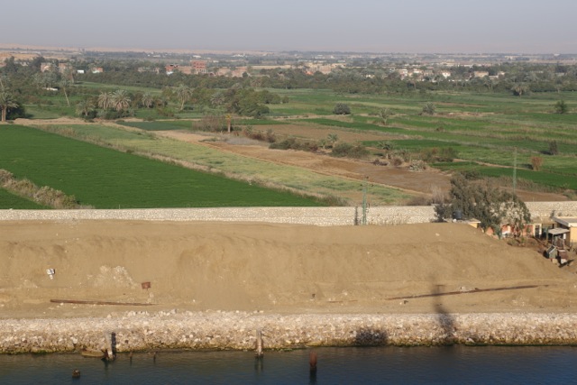
This picture looks toward the Africa side of the canal showing some of the fields.

This picture was taken at the entrance of the new section of the canal. Construction was started in August 2014 and opened on 2/24/2016.
This picture shows the old (Above) and the new (Below) part of the Suez Canal.

This picture was taken while the ship was in the new section of the canal.

This picture was taken while in the new section of the canal.

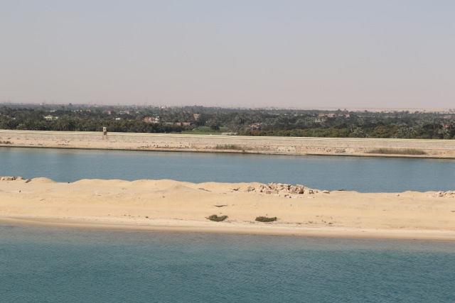
This picture is a cut out between the new and old section of the canal looking toward the old section.

This picture show a ship on the old side of the canal. It shows how high the mountains of sand that was taken out to build the new section of the canal.

This picture shows a cut out between the old and new sections of the canal.

This was a boat while we were in the new section of the canal.

This picture shows a ship in the old section of the canal which our ship is in the new section.

This picture shows some of the new construction on the Asia side of the canal.

This picture shows some of the new construction on the Asia side of the canal.

This picture looking toward the Asia of a ferry terminal.

This picture looks towards the Asia side of the canal.

This is a picture of some art work which was part of the new canal construction.

This is a picture of some art work which was part of the new canal construction.

This is a picture of some art work which was part of the new canal construction.

This picture shows some of the new construction on the Asia side of the canal.

This picture was taken while the ship was in the new section of the canal.

This picture was taken at the end of the new section of the Canal.

This picture looks towards the African side showing what looks like some rice fields.

This picture shows the Mubrak Peace Bridge looking toward the African side of the Canal.

This picture shows the Mubrak Peace Bridge looking toward the Asia side of the Canal.

This picture shows the ship passing under the Mubrak Peace Bridge.

This picture shows the Mubrak Peace Bridge from the back side


This picture shows the Mubrak Peace Bridge from the back side.

This picture looks toward the African side of the canal. I assume that the water in this canal comes from the Nile river.

This picture looks towards the African side of the Canal.

This picture looks towards the Africa side of the canal.

This picture looks toward the Asia side of the canal.

This picture was taken at the end of the Suez Canal showing some of the new ship terminals under construction.

This picture was taken near the exit of the Suez Canal.
No comments:
Post a Comment